

Quantum-Systems Trinity F90+ Vertical Take Off & Landing eVTOL Drone Equipped With The Qube240 LiDAR Sensor
Time to add LIDAR to your portfolio
Time to add LIDAR to your portfolio
A small and powerful LiDAR sensor for the Trinity F90+ UAS
• Geomatics Grade LiDAR
• Class 1 (Eye Safe)
• Wave length: 905 nm
• Maximum altitude: 140 m AGL
• Precision: 1.8-2.5 cm
• Accuracy: < 3cm
• Scanner field of view: 70°
• 240,000 shorts per second
• Point density @ 100m: 50-100 points/m²
• Multi-echo technology: up to 3 echoes per shot
• Applanix POSPacTM UAV, GNSS, and INS software for PPK
• Qube 240 data processing software to generate survey-grade LAS Files

A geomatics grade LiDAR solution from a single source
The Qube 240 LiDAR provides essential information for surveying and mapping by generating an accurate 3D image of the process environment through 240,000 distance measurements per second.
Outstanding absolute accuracy is achieved with the help of the integrated Applanix APX15 INS. One can speak of a geodetic accuracy that was previously only achievable with LiDAR Systems of the upper price segment. The easy handling and user-friendly integration will convince customers. Fast and easy processing of the raw data is an additional benefit.
The solution comes with YellowScan CloudStation software which is enclosed in an adapted variant with a 1-year subscription license.
Key Benefits of the Qube 240 LiDAR Payload:
Efficient, high-resolution, and perfectly aligned
A perfect match of high-resolution point clouds surveyed with 5 parallel runs at 100m altitude above ground. The result shows the perfect alignment of the separate runs with an extremely low level of noise. The Trinity F90+ was mapping an area of 50ha in about 10 minutes of flight time.
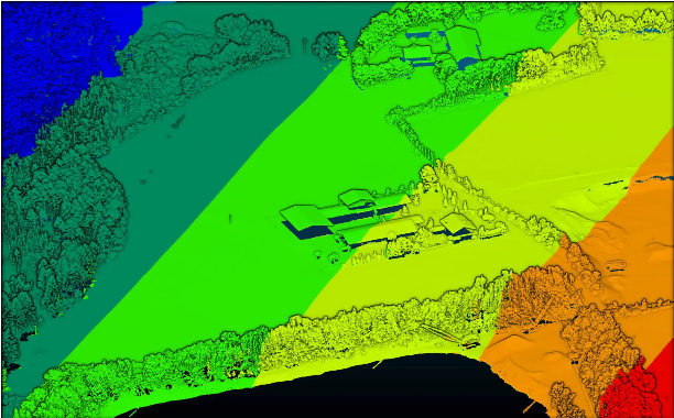
Elevations surveyed without compromise
The elevation measured from 100m above ground. The excavator in the lower right corner is a good example to illustrate the resolution and precision of the Qube 240 LiDAR. The terrain, as well as buildings and vegetation such as trees, are also clearly visible.

Automatic classification of ground points
The bench of the quarry pond in the lower part of the images is clearly shown. The Qube 240 with 3 echoes and 240,000 points per second provides a great penetration of the vegetation and therefore this LiDAR system is the right tool to survey terrain covered by trees and bushes.
